Civilization arrived in Western Washington when the Hudson Bay Company of London arrived in Vancouver.
Less than 150 people lived in Fort Vancouver in 1844 when Washington-bound Americans started arriving from over the Oregon Trail. Vancouver seemed like a metropolis in the wilderness.
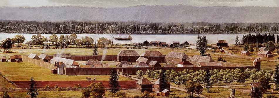 View of Hudson Bay
Company's Fort Vancouver in 1845 -
National Park Service painting by Richard
Schlect
|
The native people in Western Washington traveled between seasonal villages depending on hunting, fishing, gathering plants. Roads were the least practical means of transportation. Dense forests and tangled wetlands made travel very difficult. Therefore canoes and boats were used until after 1850 when settlers arrived from over the Oregon Trail.(1) King and Pierce Counties were crisscrossed by lakes and rivers. Trails (portages) were used to connect these water bodies to the bays and inlets of Puget Sound. The interconnection of these waterways and their proximity to higher areas made water the logical choice of transportation. Shallow draft, flat-bottomed canoes were used by natives as well as settlers and military.
That first American party over the Oregon Trail to Western Washington consisted of 31 people. There was no road from the Cowlitz River to Tumwater so the Hudson Bay Company trail was widened by the party enough to allow their wagons to pass the huge trees.(2)(3). Like many of the other trail systems in use during the time, it was originally a native trail, later used by traders, missionaries and military. By the late 1840's newly arrived immigrants had no other overland alternative since it was the only trail that could accommodate wagons, livestock and supplies. Settlers arriving from over the Oregon Trail would float down the Columbia River as far as the mouth of the Cowlitz River. From there they would hire Indians with a canoe or bateau to paddle up the Cowlitz to where Toledo is now located. From there they would travel overland to Olympia and by boat to points further north in Puget Sound. The Cowlitz Trail was always muddy and at Chehalis (Saunders' Bottom) wagons required special care to make their way.(4)
When settlers first arrived in Western Washington, the Hudson Bay Company already had parts of Clark, Pierce and Cowlitz Counties under cultivation. These farms provided goods to the forts at Vancouver, Nisqually, and Langley, B.C. as well as Russian trade in Alaska. Fort Nisqually was built near DuPont in 1832 to provide security from the Indians, prairies for grazing, good anchorage, and as a halfway point between Fort Vancouver and Fort Langley. In 1833 the first white man to explore near Sumner was Dr. William Tolmie from Inverness, Scotland who later became chief manager at Fort Nisqually (1843-59).(5) Fur trappers may have passed through the White River area previously as they were delivering furs to Fort Nisqually. Fort Nisqually was manned by British, French-Canadians, Native Americans, and a few Americans. Scouts from these two forts probably made excursions into the White River area before 1850. The Hudson Bay Company left Washington after the 49th parallel became the US-Canadian boundary in 1846. The U.S. Government established Fort Steilacoom (now site of Western State Hospital) in 1849 just south of Fort Nisqually to secure American interests in the Puget Sound area.
Stage Coaches
Western Washington never had the luxury of stage coaches as in other parts of the country as there were few roads. Stage coaches were popular in New England. Nearly the only stage coach route was from Toledo to Olympia and that was over the treacherous Cowlitz Trail from 1852 to 1856 until the start of Indian Wars.(6, p. 44)(7) After the Wars ended in 1857 other stage coaches ran that route. However in 1857 the Military Road was completed by volunteers between Fort Vancouver and Steilacoom and the road was better. Mail service was established in 1852 with stage coaches from Toledo to Olympia.(8)(9)
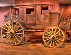 |
| The Concord stage coach made by Abbot-Downing of Concord, New Hampshire (1827-1898) was the most popular of its kind. It had special suspension made with leather straps which gave a swinging motion instead of jolting up and down. The stage coach route via the Cowlitz Corridor ended when the Northern Pacific Railway was built in 1874 from Kalama to Olympia - Northwest Carriage Museum, Raymond WA. |
The first major roads constructed after the Cowlitz Trail were the Military Roads from Fort Steilacoom to Walla Walla and then later from Fort Steilacoom to Fort Bellingham. The Military Road near the City of Pacific was in such bad condition that it was not used during the Indian Wars of 1855-56. The road from Steilacoom to Seattle was financed with $35,000 by an act of Congress in 1857. (10)
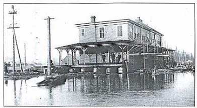
Steamboats Despite the Military Road, overland travel through the dense forest remained difficult, especially in the winter, and mail service (beginning in 1879 in the Federal Way area) was via boat to the small settlements on Puget Sound especially at Adelaide (near Dash Point) and was distributed by horseback riders.(11) In March 1847 Congress passed the Mail Steamer Bill which authorized $290,000 in annual subsidies for a line of steamships sailing twice per month between New York and Chagres, Panama which was on the Atlantic coast. To complete the trip to Oregon Territory monthly service was provided from Panama City, Panama to Astoria which was the first post office west of the Rocky Mountains. After 1855 mail required less than 40 days to travel from New York to San Francisco (including crossing Panama)(12) and another 3 days to Astoria.(13) Mail was sent to and from "The States" mainly in this manner until the first transcontinental railway was completed in 1869. The Pony Express operated for only 19 months 1860-61.(14) The mail from Portland to the Puget Sound was not delivered on a regular basis until stage coach service over the new Military Road from Fort Vancouver to Fort Steilacoom was established.(15) The first telegraph message was sent from Seattle in 1864 (16) marking the end of dependence on mail for communication. Sailing ships were often used between the Puget Sound and San Francisco and other ports, but steamboats were favored within Puget Sound. In 1880 Seattle had a population of 3,500 and was just beginning its dramatic rise to prominence not only in Puget Sound, but throughout the Pacific Northwest as well. Until 1880 Puget Sound remained outside the currents of transportation history, which before then always seemed to flow around the Columbia River and Portland north of California. With a population of 17,500 in 1880 Portland remained the center of trade and commerce. Seattle began to grow quickly after gold was discovered in the Yukon. Various sawmill towns sprang up around Puget Sound. Seattle was no larger than others, however, Henry Yesler's was the first steam sawmill on Puget Sound and spurred Seattle's growth. The Hudson Bay Company ran the Beaver steamboat in Puget Sound starting in 1836. American steamboats began with the small sidewheeler Fairy in 1853 on a route between Olympia and Seattle which took at least one day. Fare was an expensive $10 one way. The Fairy carried mail during the Indian Wars. Unfortunately the Fairy exploded in 1857. The Fairy was the first steamboat to carry mail in Puget Sound.(17, p. 328) (18) The first really successful steamboat was the iron propeller Traveler which alternated directions each week between Seattle and Olympia and stopped at at all intermediate points.(19)(20) The 85 foot Traveler was also the first steamboat to navigate the Snohomish, Nooksack, and Green Rivers starting in 1855. "Previous to the operation of the Northern Pacific Railway between Seattle and Tacoma [in 1887], steamboats made regular trips up the Duwamish and up the White [later Green] River for 15 miles farther" (A.J. McMillan, 1890, in War Department, 1891, Appendix to Annual Report to Chief of Engineers, U.S. Army). In 1856 the Traveler ascended to Fort Dent (Black River) and then on to Fort Thomas (six miles north of Auburn on the John Thomas claim) just south of Kent. There was also a landing that was popular on the property of Irving Thomas Alvord. At the peak of this era five or six sternwheelers regularly plied this stream 1860 to 1887.(21, p.23) The Traveler repeated this trip many times.(22)
Other steamboats to travel the Green River were the Comet, Gem, Black Diamond, and Zephyr. (25) The trip from Seattle to Alvord's landing upstream (about 2 miles north of Emerald Downs) required less than 14 hours.(26) The next steamboat on the Sound was the Major Tompkins arriving from San Francisco in 1854. This iron, propeller-driven boat rarely traveled over 5 miles per hour, but carried passengers, freight and mail between Olympia and Victoria. The Major Tompkins wrecked near Victoria after only about one year.(27) After the gold rush to Frazer River in 1858, many steamboats plied Puget Sound waters.(28) Railroads in King County in 1909
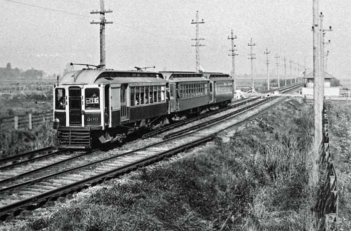
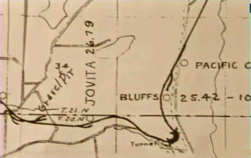
Intercontinental Railroads to King County Although the Northern Pacific and other railroads were slow to come to King County, early transportation would not be complete without discussing the intercontinental railroads.(29) Interurban railway The area now called City of Pacific was separated from other parts of King and Pierce Counties because of the primitive early roads. Horses and wagons were the main form of transportation. Electric interurban railways played a major part in defining early twentieth century transportation routes and growth patterns.(30) The interurban railway in the City of Pacific was a part of the giant Stone and Webster Management Company of Boston. Stone and Webster had purchased the hydroelectric dam at Snoqualmie Falls and 22 electric street car lines in Seattle by about 1900. The Seattle to Tacoma Interurban had been launched by Tacoma attorney and industrialist Henry Bucey in 1899, but that company was in financial trouble.(31) In 1901 Stone and Webster bought and renamed this bankrupt company "Seattle Electric Company" managed by Jacob Furth of Puget Sound National Bank. The 38 mile long line was named the Puget Sound Electric Railway and was quickly completed in September 1902.(32) The route passed through the Jovita Creek Canyon which created construction delays and maintenance headaches due to landslides along the steep hillside. A tunnel over 175 feet long at Stewart's Point was required to finish the project.(33) One station was placed at 3rd Avenue in the City of Pacific. Another station was built at Bluffs, about one quarter mile north of the county line, just west of the West Valley Highway.(34) To cross over the Highway, a steel railway bridge was built in 1915 near Bluffs Station when the West Valley Highway was paved with bricks.(35)
The Interurban was an instant success carrying commuters, military passengers, and recreation passengers during the day and farm, coal, and wood products especially at night. Fares began at $1.00 for Seattle to Tacoma round trip including street car transfers in the cities. The express train took just 90 minutes from Seattle to Tacoma (stopping in Auburn and Kent). However, cars and roads emerged within a few years. The Interurban Electric Railway closed in 1928 after carrying millions of passengers every year.(39)
|


The Naches Trail which was blazed in 1853, but never became popular as a crossing over the Cascades. Following the Indian Wars in 1857, the Naches Pass was used mainly by stockmen until 1900. The Snoqualmie Pass was favored by pack trains starting in 1867, but was rarely used by wagon trains.(40)
Transportation pioneers were driven by the crush of gold seekers. Here are the changes in population 1849 to 1860.(41)
| 1849 |
1860 |
|
| San Francisco |
1,000 |
57,000 |
| Portland |
800 |
3,000 |
| Seattle |
0 |
188 |
Much as San Francisco was the leader of transportation on the West coast, so was it with communication. San Francisco received mail by ship from the East coast starting in 1847 (42 p.184). The Puget Sound area did not receive mail until 1860 from the East coast.(43, p.92) Telegraph came to San Francisco in 1861, but did not arrive in Seattle until 1864.
| Year |
Population
of Pacific, WA (44) |
| 1900
(est.) |
<100 |
| 1910 |
413 |
| 1920 |
320 |
| 1930 |
347 |
| 1940 |
357 |
| 1950 |
755 |
| 1960 |
1,577 |
| 1970 |
1,831 |
| 1980 |
2,261 |
| 1990 |
4,622 |
| 2000 |
5,527 |
| 2010 |
7,123 |
| 2020 (est.) |
9,324 |
Early Roads
For centuries Native Americans inhabited the area that encompasses King County. Travel between settlements, as well as to and from resource areas, did necessitate some overland travel. In these instances, trails provided the shorter– if more challenging–route.(45)
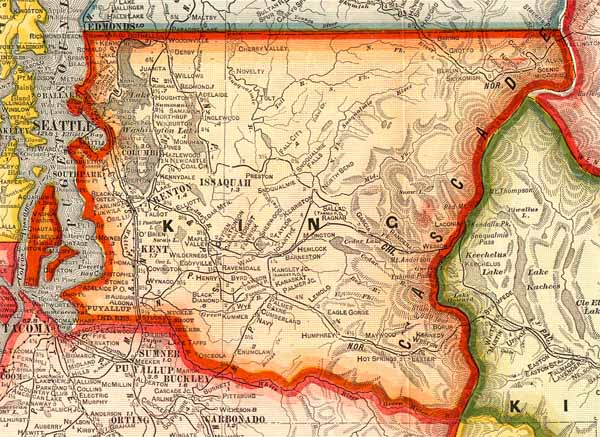
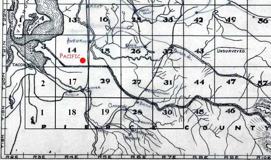
After the City of Pacific was incorporated in 1909 the development of roads became more important since automobiles soon became the primary mode of transportation. Here are the roads around Pacific in 1907. Click map to enlarge.
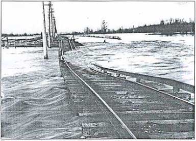
The West Valley Highway (formerly the Pacific Highway) became an important main road marking the decline of the Puget Sound Electric Railway. The Highway was fully paved from Seattle to Tacoma in Janaury 1915. The stretch of road near Orillia was the first brick paved highway west of the Rocky Mountains in 1912. Brick paving soon stretched from the Pierce-King County line to Everett.(46)(47) Just as the Highway was paved in 1914, a steel bridge was installed for the Interurban. The bridge passed over the Pacific Highway about 1,000 feet north of the County line, thus eliminating a dangerous crossing. The Pierce County section of the Highway further south consisted of concrete and asphalt at this time.
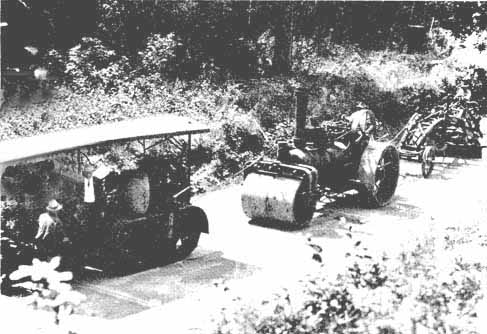 |
| View of the steam tractor, roller
and grader used to pave the Pacific Highway near
Kent in about 1912 - White River Valley Museum |
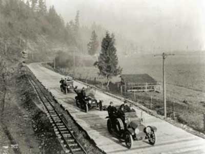 |
| The Pacific Highway looking northwest in 1915. The Bluffs Interurban Station is located in the deep background just at the curve in the Highway. Planks were placed over the finished brick road only temporarily in 1915 as a precaution to allow the five inch concrete base to dry thoroughly.(48)(49) The narrow gauge tracks were used only for the construction of the 20 foot wide paved Highway. This view is from approximately 735 West Valley Highway South today - Museum of History and Industry, Seattle. |
The Pacific Highway followed pioneer roads from Blaine to Seattle. From Seattle to Olympia it followed the Military Road. From Olympia to Toledo it followed the old Cowilitz Trail. From Toledo to Vancouver it followed the route chosen by early trappers, settlers, and military. The Pacific Highway in 1923 formed a part of the longest continuous road in the world at the time (1,687 miles). The Highway was later was extended from Vancouver BC to San Diego.(50)
Roads became a more prevalent 1900 to 1928 as lumber, agriculture, and mines looked for a way to transport their products. Improvements in transportation (especially the Interurban Electric Railway) spawned suburbs to Seattle and Tacoma. Residents were allowed to live further from work centers, spreading more people to the City of Pacific. There were competing transportation systems. The Mosquito Fleet, which was popular through the 1920's, which included hundreds of steamboats, began to decline.(51) Passenger ferries were converted to car ferries. Diesel-electric boats began replacing steamboats. Freight steamboats were replaced by trucks. Railroads experienced competition from trucks and automobiles. Next, the airplane rapidly replaced other competing transportation systems.
The cry for better roads increased as cars became more prevalent.(52) By 1907 there were about 300 gasoline-powered vehicles registered in King County. By 1916 there were 54 miles of paved roads and over 1,400 miles of dirt and gravel roads in King County. Auto camps, service stations, lunchrooms, and motels began to appear. Snoqualmie Pass was made suitable for car traffic. Local roads became County roads and County Roads became State roads. The costs of roads in sparsely populated areas were then borne by all State tax payers. State road construction was then held to specific standards and final inspection was made by the State under the 1911 State Aid Law. Road construction and maintenance became a part of property tax in 1911. In 1916 Federal funds became available to build and improve roads. Paving became a priority. In 1919 the State Legislature appropriated funds for and began construction of roads connecting the principal cities of the State. Steamboats were retrofitted to carry cars in 1920 serving as the beginning of the Washington State Ferry System. In 1929 the State Department of Highways was created with a Director appointed by the Governor. Road construction was shifted from local to State control.(53)
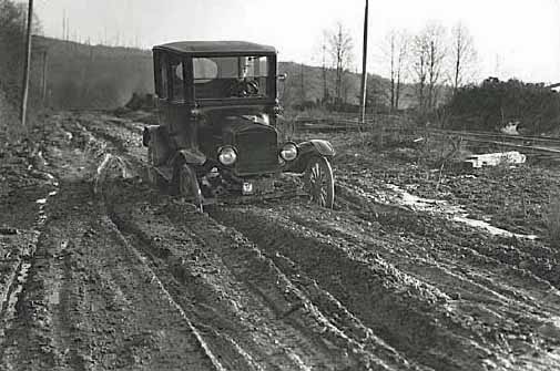 |
| Dirt road in King County in
1926. 1922 Model T Ford Coupe. Cars were
built to handle the muddy roads - Museum of
Science and Industry. (54) |